|
GlacierDogMapMe searches out and maps extraordinary places!
And God saw every thing that He had made, and, behold, it was very good. ... Genesis
1:31
----------
GlacierDog MapMe: Pantheon, Vatican, Washington DC - What
Were They Thinking!?
 GlacierDogMapMe:
Pantheon, Vatican, Washington DC - What Were They Thinking!?
Why is there a Dome facing an Obelisk in the Pantheon?
Why is there a Dome facing an Obelisk at the Vatican?
Why is there a Dome facing an Obelisk in DC?
Why are they all the same? GlacierDog thinks it is all very strange.
Here’s some thoughts by Dr. Thomas R. Horn
and raidersnewsupdate:
“Washington DC was designed as a symbol of the Rosicrucian dream shared by its builders: that America would
become the New Atlantis and eventually lead the world into a restored Golden Age of Osiris.” “…
a design based on “The Roman Pantheon--the circular Domed rotunda dedicated to all pagan gods--was suggested
by Jefferson…” …“Unrecognized by the vast majority of peoples around the world is the greatest conspiracy of all time,
sitting right out in the open in Washington DC and at the Vatican. It is an ancient, magical, talismanic diagram--the Lost
Symbol--based on the history and cult of Isis, Osiris, Horus, and the prophecy of the deity’s return. The
primeval concept was designed in antiquity for the express purpose of regeneration, resurrection, and apotheosis, for deity
incarnation from the underworld to earth’s surface through union of the respective figures--the Dome (ancient structural
representation of the womb of Isis) and the Obelisk (ancient representation of the erect male phallus of Osiris)…” Ref: http://www.raidersnewsupdate.com/leadstory70.htm with
excerpts from Apollyon Rising 2012 GlacierDog thought the US Constitution
protects us from the establishment of a government-sponsored religion. Have you seen the painting on the
ceiling of the Capital Dome called the “Apotheosis of George Washington” and all the Roman, Egyptian, and Greek
deities decorating DC? Pretty weird… What Were They Thinking!?
----------
GlacierDog MapMe: Is There a Planet Made of Diamonds?
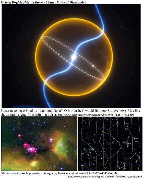 GlacierDogMapMe: Is there a Planet Made of Diamonds? * A planet made of diamond crystals has been discovered in the Milky Way’s plane
of stars in the constellation of Serpens. * The “Diamond Planet” has a 2 hr, 10 min orbit around fast-spinning pulsar
J1719-1438. J1719-1438 is called a millisecond pulsar and rotates more than 10,000 times/minute.
The planet is at a very close distance of 600,000 km to its pulsar. In fact, it is so close, it
is believed that if the planet was larger, the pulsar’s gravity could rip it apart. * The planet is very dense and
believed to possibly be all that remains of a once-massive star, most of whose matter was siphoned off towards the pulsar.
It is believed to be largely carbon and oxygen, crystalline, and a large part of it may be similar to a
diamond. What an interesting place this
would be to see up close!
Refs: http://www.eurekalert.org/pub_releases/2011-08/uom-apm082311.php http://www.wired.com/wiredscience/2011/08/diamond-planet/
GlacierDog
also does books - math, weight-loss & time-travel: http://www.glacierdogpublishing.com/
----------
GlacierDog MapMe: Is It a Planet or a "Failed Star"?
 GlacierDogMapMe:
Is it a Planet or a “Failed Star”? * This “massive, puffed-up oddity” planet is located in the constellation
Andromeda. Called, KELT-1b, it is so massive that it may better be described as a ‘failed
star’ rather than a planet. A super hot, super dense ball of metallic hydrogen, KELT-1b is located
so close to its star that it whips through an entire “yearly” orbit in a little over a day - all the while being
blasted by six thousand times the radiation Earth receives from the sun. It is one of the most bizarre
transiting companions ever detected. The planet is slightly larger than Jupiter, but contains 27 times
the mass. Thus, it qualifies as a ‘failed star,’ or “brown dwarf.” “This
is the first definitively ‘inflated’ brown dwarf found, and exactly how this happened is a complete mystery that
should keep theorists busy for a while,” Gaudi said. KELT-1b is a strange
world, indeed. If you could stand on the surface, the “sun” would take up one quarter of the
sky overhead. Although it is made primarily of hydrogen, it is so massive and compressed
that its density matches that of the densest naturally occurring element on Earth: osmium - a shiny, bluish metal found in
platinum ore that is approximately twice as dense as lead. Because it orbits its host star once every 30
hours, a solar “year” on KELT-1b passes in a little more than one Earth day. And because it
orbits so closely, it is blasted with 6,000 times the amount of stellar radiation than we are exposed to on Earth. Its
surface temperature is likely above 4,000°F (about 2,200°C). By comparison, the planet Mercury
orbits our sun once every 88 days, and the hottest temperature on the surface reaches only 800°F (more than 425°C). * Fewer
than 1 percent of the extrasolar planets ever discovered have been both extremely massive and extremely close to their host
stars. “This is a great system for studying orbital dynamics,” said Siverd, who is the lead
investigator on the KELT-1 discovery. “It has the strongest tides of any brown dwarf system found
so far,” he added.
http://www.dailygalaxy.com/my_weblog/2012/06/two-new-alien-planets-discovered-in-andromeda-resets-the-bar-for-weird.htmlGlacierDog also does books - math, diet & time-travel: http://www.glacierdogpublishing.com/
----------
GlacierDog MapMe: Where Was the Largest Volcanic Eruption
of the 20th Century?
 GlacierDogMapMe:
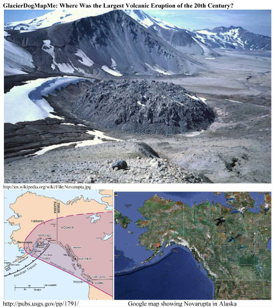
Where Was the Largest Volcanic Eruption of the 20th Century? * 100 years ago in June 1912, the 20th century experienced its largest, most voluminous, explosive
volcanic eruption. It occured in Alaska and formed the huge lava dome, Novarupta. In
what is now Katmai National Park and Preserve, over 3 cubic miles (about 13.5 cubic kilometers) of magma blasted through the
floor of a broad glacial valley for 60 hours. Clouds of ash rose high into the atmosphere and drifted downwind,
dropping more than a foot of ash on Kodiak, dusting Puget Sound, and eventually circling the globe. The
ash and gas cloud colored the Mediterranean sky and measurably depressed global temperatures. The eruption
was also correlated with some 50 earthquakes recorded at distant seismic stations (including 14 shocks of magnitude 6.0 to
7.0) and produced a series of ash flows that filled what became the Valley of Ten Thousand Smokes. * 6 miles from
erupting Novarupta, Mount Katmai collapsed into a deep, steep-walled, steaming crater. For
many years Katmai was believed to be the volcano creating the massive eruption. But in the 1950s geologist
Garniss Curtis carefully mapped ash thicknesses that identified Novarupta as the culprit.
Refs: http://www.avo.alaska.edu/Katmai2012/timeline.php; http://pubs.usgs.gov/pp/1791/ GlacierDog’s Website: http://www.glacierdogpublishing.com/
----------
GlacierDog MapMe Finds Massive Amount of Water in a Surprising
Place!
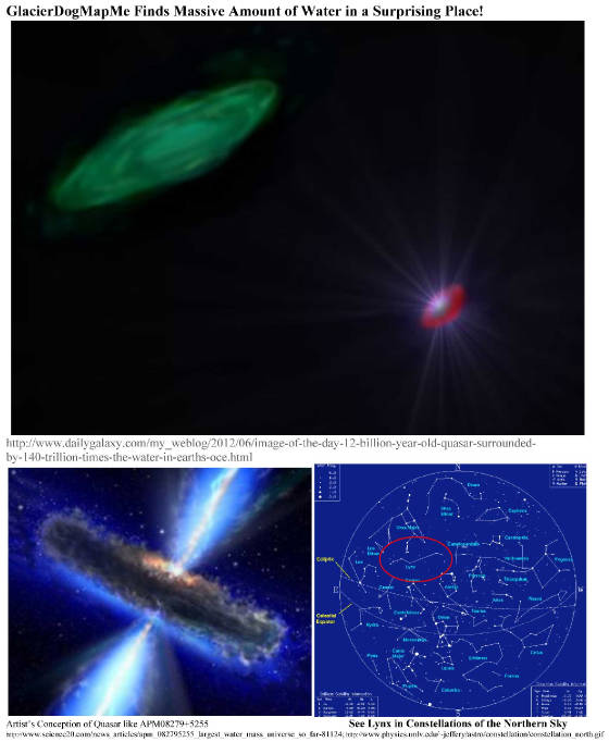 GlacierDogMapMe Finds Massive Amount of Water in a Surprising Place! * In 2011, astronomers discovered the largest and farthest reservoir of water
ever detected in a quasar more than 12 billion light-years away
called APM 08279+5255! The water is equivalent to 140 trillion times all the water
in Earth’s oceans. * Quasar APM 08279+5255 is one of the most powerful known objects in the universe and
has an energy output of 1,000 trillion suns. * A quasar is powered
by a massive black hole that steadily consumes a surrounding disk of gas and dust. As it sucks everything
in, the quasar spews out huge amounts of energy. * In this particular quasar, the water vapor
is distributed around the black hole in a gaseous region spanning hundreds of light-years in size (a light-year is about six
trillion miles). The environment around quasar APM 08279+5255 is thought to be
unique since it is producing such a large mass of water. The quasar is bathing the surrounding gas in X-rays
and infrared radiation, and the gas appears to be unusually warm and dense. *
By comparison, in our Milky Way, the mass of gaseous water is found in
a limited number of regions and is some 4,000 times smaller than that in the quasar.
Most of the water in the Milky Way galaxy is frozen into ice. http://www.dailygalaxy.com/my_weblog/2012/06/image-of-the-day-12-billion-year-old-quasar-surrounded-by-140-trillion-times-the-water-in-earths-oce.html http://www.science20.com/news_articles/apm_082795255_largest_water_mass_universe_so_far-81124 GlacierDog’s Website: http://www.glacierdogpublishing.com/
----------
GlacierDog MapMe Finds Evidence of Ancient Life in an Unlikely
Place!
 GlacierDogMapMe
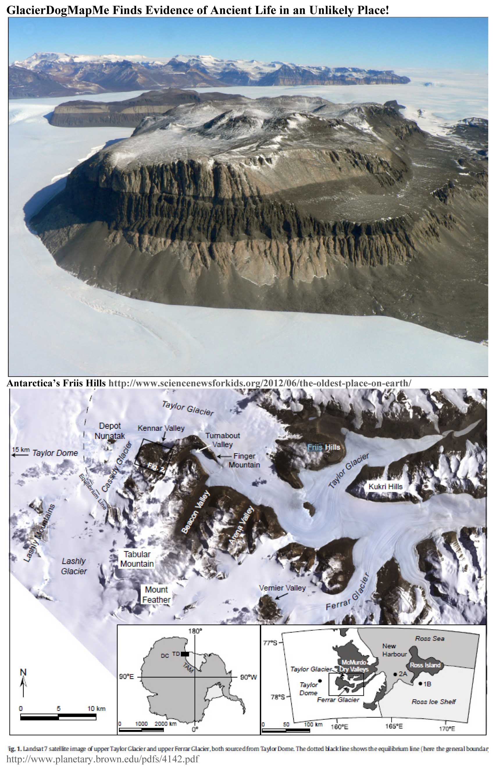
Finds Evidence of Ancient Life in an Unlikely Place! * Just below the surface of crumbly dirt in the year 2005, Lewis and Ashworth discover dead
beetles, wooden twigs, pieces of dried moss, and bits of other plants. Where? The Friis
Hills in Antarctica! Today, the Friis Hills, which sit on a flattop mountain, 60 km (37 mi) from the coast,
experience cold winds shooting off the Antarctic Ice Sheet, some 30 km farther inland. The Friis Hills
see -50°Celsius (-58°F) winter temperatures, and even a warm summer day rarely exceeds
-5°C (23°F). When Lewis and Ashworth placed those bits of the ancient
frozen moss in water, the plants swelled into tiny soft, squishy sponges. * The Friis Hills are a 6 mile-long,
1,750 meter (5,741.5 ft) high cluster of hills at the north side of the bend in Taylor Glacier in Victoria Land. * Today Antarctica
is barren and icy, void of much life other than seals, penguins, and other birds along the shores. However,
the ancient bits of bugs and plants discovered by Lewis and Ashworth reveal a different past - one filled with moss, various
critters, and forests of leafy trees! * Nevertheless, even today, Antarctica’s terrain is not completely dead.
Small regions of bare, ice-free rock can hide crevices with a faint crust of green algae-stained
dirt housing a few creepy-crawly critters which may include worms, tiny flies, six-legged springtails, or small eight-legged
mites that are related to ticks. http://www.sciencenewsforkids.org/2012/06/the-oldest-place-on-earth/ GlacierDog’s
Website: http://www.glacierdogpublishing.com/
----------
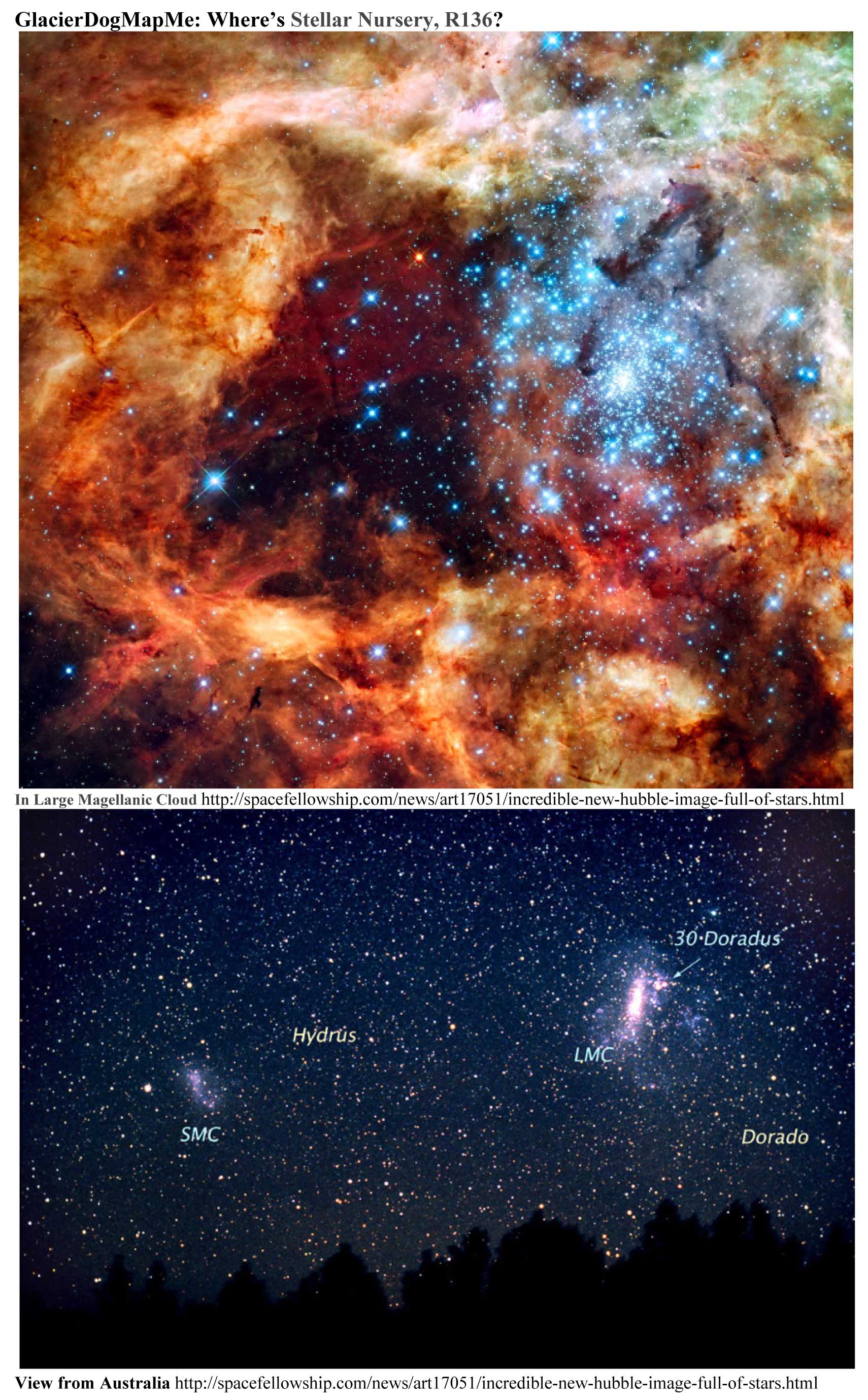
GlacierDog MapMe is Still in Space - Where's Stellar Nursery
R136?
GlacierDogMapMe
is Still in Space - Where’s Stellar Nursery R136? Wow! *
This Hubble image (taken Oct. 20-27, 2009)
displays the spectacular power of the Creator at work in the largest stellar nursery
in our local galactic neighborhood! * This massive stellar grouping called R136 is
in the 30 Doradus Nebula, a highly active star-forming region in the nearby Large Magellanic Cloud (LMC). The icy-blue stars
are among the most massive stars known. *
The Large Magellanic Cloud is 170,000 light-years away and is a member of the Local Group of Galaxies, which also includes
the Milky Way. “The image, taken in ultraviolet, visible, and red light by Hubble’s Wide Field Camera 3, spans
about 100 light-years.” Source: http://spacefellowship.com/news/art17051/incredible-new-hubble-image-full-of-stars.html GlacierDog’s Website: http://www.glacierdogpublishing.com/
----------
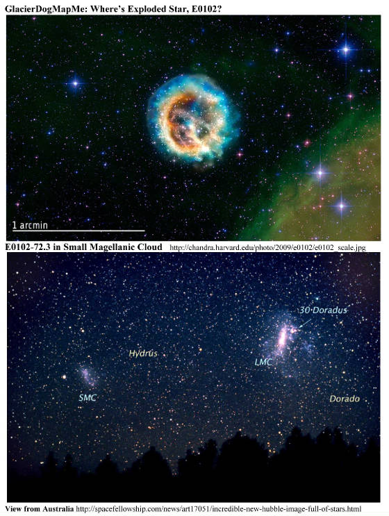
GlacierDog Leaves Earth - Where's Exploded Star, E0102?
GlacierDog
Leaves Earth - Where’s Exploded Star, E0102? Wow!
*
“E0102 is the debris of a very massive star that exploded in the neighboring galaxy known as the Small Magellanic Cloud
[SMC]. Chandra first looked at this object nearly ten years ago, just months after the telescope was launched.
Analysis of new Chandra data gives information on the geometry of the supernova explosion. The best
model based on the data is that the ejecta is shaped like a cylinder that we see end-on.” *
The Small Magellanic Cloud is a neighbor at only 190,000 light years from our Milky Way. http://chandra.harvard.edu/photo/2009/e0102/?utm_source=twitterfeed&utm_medium=twitter; http://chandra.harvard.edu/photo/2009/e0102/e0102_smc.jpg GlacierDog’s Website: http://www.glacierdogpublishing.com/
----------
GlacierDogMapMe: Where and What Is "Denali"?
 GlacierDogMAPME: Where and What Is Denali? * Denali, also
called Mount McKinley, is North America’s tallest peak at 20,320 feet and is located in Alaska about 150 mi NNW of Anchorage.
“Measured from the 2,000-foot lowlands to its snowy summit at 20,320 feet, the mountain’s vertical
relief of 18,000 feet is greater than that of Mount Everest.” http://www.nps.gov/dena/ * While temperatures at Denali’s summit are severe even during the summer, winds can gust to
over 150 mph and the winter temps at an elevation of just 14,500 feet can dive to colder than -95°F! Permanent
snowfields cover more than 50% of the mountain, feeding its many glaciers. Denali’s granite
and slate core is covered by ice that in some areas is hundreds of feet thick. * “Denali”,
meaning the “High One” in native Athabascan language, crowns in the Alaska Range in a huge national park. The
park and the mountain were first named for President William McKinley, but later renamed Denali National Park and Preserve.
The mountain now goes by either Denali or Mount McKinley. * Denali Park is a largely unspoiled wilderness. In addition to viewing the mountain, visitors can
spend the incredibly long summer days taking wildlife tours and are able to see moose, bear, Dall sheep, goats, and eagles.
http://www.nps.gov/dena/ and http://www.nature.nps.gov/geology/parks/dena/ GlacierDog’s Website: http://www.glacierdogpublishing.com/
----------
GlacierDogMapMe: Where and What Is "Giant's Causeway"?
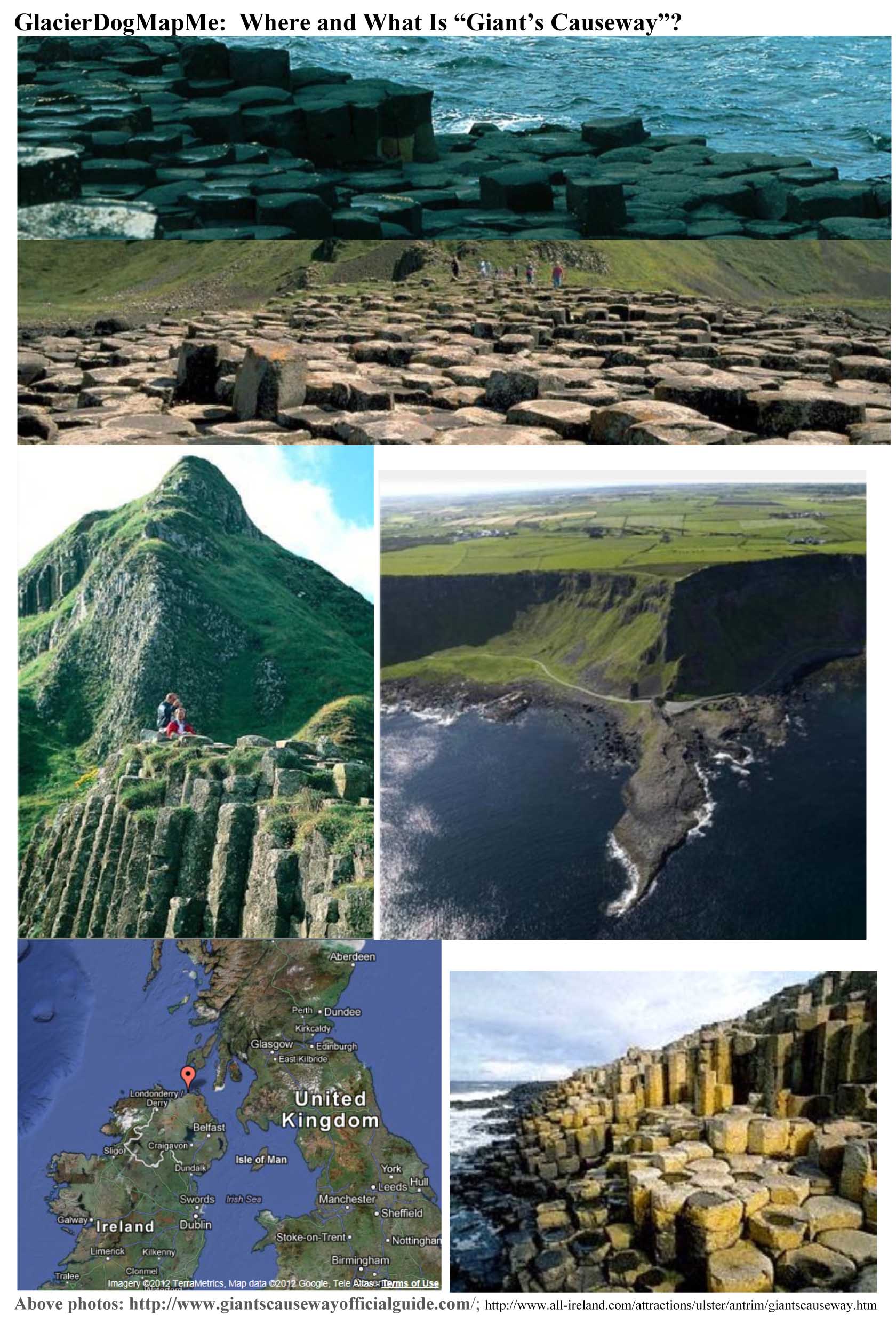 GlacierDogMapMe:
Where and What Is “Giant’s Causeway”? * The Giant’s Causeway is an
area of thousands of volcanic basalt columns on the north coast of Northern Ireland. The columns are mostly
hexagonal-shaped, though some have up to eight sides. The columns can reach heights of nearly 40 feet. * How
did it form? Volcanic action. “… highly fluid molten rock was forced up through
fissures in the chalk bed to form an extensive lava plateau. … The rapidly cooling lava contracted and variations in
the cooling rate resulted in the world famous columnar structure.” http://www.giantscausewayofficialguide.com * The lore: The Causeway was built by legendary
giant Fionn mac Cumhaill, Anglicized as Finn McCool, due to an ongoing rivalry between him and another
giant in Scotland, Benadonner, or Benandonner. Finn built the Causeway between the two countries so they could have a trial
of strength. http://www.all-ireland.com/attractions/ulster/antrim/giantscauseway.htm
Sponsored by: http://www.glacierdogpublishing.com/
----------
GlacierDogMapMe: Where and What Is "IceCube"?
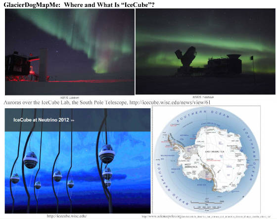 GlacierDogMapMe: Where and What Is “IceCube”?
* “The IceCube Neutrino Observatory is a high energy neutrino telescope
built into the ice under the geographical South Pole.” More specifically, “IceCube
is a particle detector at the South Pole that records the interactions of a nearly massless sub-atomic particle called the
neutrino. IceCube searches for neutrinos from the most violent astrophysical sources: events like exploding stars, gamma ray
bursts, and cataclysmic phenomena involving black holes and neutron stars. The IceCube telescope is a powerful tool to search
for dark matter, and could reveal the new physical processes associated with the enigmatic origin of the highest energy particles
in nature.” * “Since
neutrinos have a very small mass, they are hard to detect. IceCube uses the ice at the South Pole in Antarctica to hold basketball
sized detectors called digital optical modules, or DOMs. Altogether, there are over 5,000 DOMs in the ice.” * Ice is helpful “...when a neutrino interacts with an atom of ice, a particle
called a muon is produced. The muon radiates blue light that is detected by the DOMs. The direction and intensity of the light
allows us to determine where the neutrino was coming from in the Universe.” * The South Pole has a lot of ice, providing the perfect
location for this huge neutrino detector. “It uses a cubic kilometer of ice and is the largest neutrino detector in
the world.” * By the way, Antarctica is the world’s coldest, driest, and windiest place, having the world's lowest recorded
temperature of -128° F (~ -89° C) measured at the Russia Vostok Station. Antarctica’s temperature rarely exceeds
32° F (0° C), and the highest recorded South Pole temperature is 7° F (-13.8° C). Antarctica’s highest
recorded wind speed was measured at 320 km/h (200 mph) in July 1972 at the French Dumont d'Urville base.
----------- GlacierDogMapMe: Where Is Tiwanaku (Tihuanacu, Tihuanaco) and why should you
care?
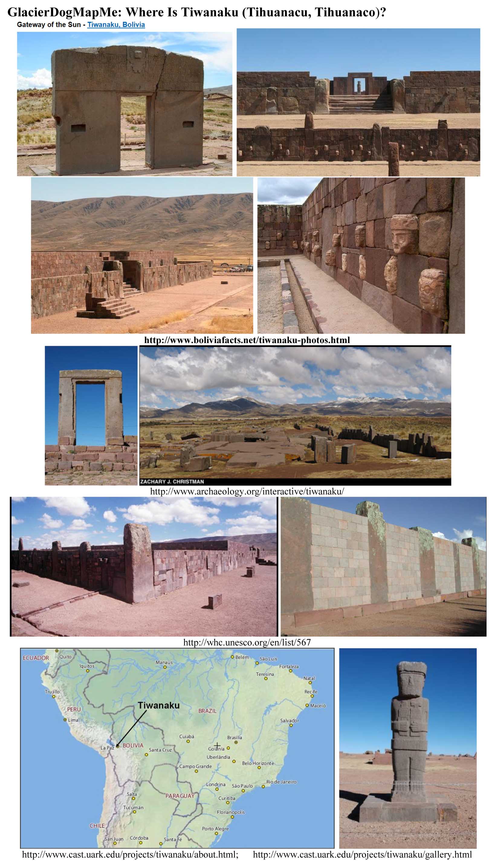 GlacierDogMapMe:
Where Is Tiwanaku (Tihuanacu, Tihuanaco) and why should you care? * Sometimes
called “American Stonehenge”, Tiwanaku
(or Tiahuanaco or Tiahuanacu) is an ancient archaeological site in a 13,000 ft highland
valley in the area of La Paz, Bolivia near the border of Peru. Tiwanaku is surrounded by
mountains on three sides and Lake Titicaca on the fourth. The site is
called “American Stonehenge” because massive blocks of stone, which are not
indigenous to the plateau, were somehow transported a great distance, cut precisely and geometrically, and then assembled.
* Tiwanaku is much more impressive than Stonehenge! Some have
theorized that these structures were created by a race of antediluvian giants such as those mentioned in Genesis 6 and the
extra-Biblical Book of Enoch. These giants have been reported in the lore of ancient cultures throughout the world, including
South America. * The site contains large monuments including: - Akapana pyramid: a large 16-m square
mound having seven terraced or superimposed platforms with stone walls rising to an amazing height of 18 m (60 ft). - Kalasasaya: a large, walled temple with massive upright stones marking the annual solar cycle by allowing someone
to watch the equinox Sun rise through its central eastern doorway. Its walls are huge blocks of red sandstone and andesite
created using sophisticated masonry. What is interesting is that its stone slabs, which weigh as much as 100 tons, would have
had to come from andesite quarries that were 40+ km (25 mi) away and sandstone quarries 10+ km (6 mi) away. - Puerta del
Sol (Gateway to the Sun): a 3 m (10 ft) gateway cut from a single slab of andesite stone. It has a carved deity figure
above its doorway, which is positioned such that during the Spring and Fall equinox the Sun shines through the gate onto the
figure. - Templete Semisubterraneo (Semi-subterranean Temple): believed
to represents the underworld, a 2 m deep structure that has some 175 faces carved onto its stone walls. - Pumapunku: a large rectangular, terraced platform
mound faced with megalithic blocks. It has an area called Plataforma Litica consisting of a 6.75 m by 38.72
m (22 ft x 127 ft) terrace which is paved with enormous stone slabs. One of the slabs is 7.81 m by 5.17
m (26 ft x 17 ft) and averages 1.07 m (3.5 ft) thick, with an estimated weight of about 131 metric tons (288,806 lbs).
The wall stones of Pumapunku were created to interlock with each other and fit perfectly together
without mortar to form load-bearing joints. They are cut with geometric precision creating astonishingly flat surfaces and
flush joints that are beyond what you would expect for that day. * According
to http://www.boliviafacts.net/tiwanaku.html Tiahuauaco's huge
stone monoliths were built around 600 BC remaining intact until the mysterious collapse of the society around 1,200AD.
* “One of the most puzzling aspects of the Tiwanaku pyramids is the lack of nearby quarries.
Analysis of the red sandstone places one quarry 10 kilometers away, an incredible distance considering that one of the stones
alone weighs over 130 tons. The source of the green andesite stones, the material from which the most elaborate carvings and
monoliths are made, is on the Copacabana peninsula, across Lake Titicaca.” http://www.archaeology.org/interactive/tiwanaku/project/experiment.html.
One theory is that the andesite stones were transported some 90 km on reed boat across Lake Titicaca and somehow
dragged another 10 km. http://www.edb.utexas.edu/education/centserv/csme/2955/program; http://www.archaeology.org/interactive/tiwanaku/project/; http://www.cast.uark.edu/projects/tiwanaku/geophysics-at-tiwanaku/introduction.html; http://www.upenn.edu/pennnews/news/penn-museum-begins-ground-breaking-project-create-underground-image-pre-inca-city; http://www.cast.uark.edu/projects/tiwanaku/about.html; http://en.wikipedia.org/wiki/Pumapunku Our Website: http://www.glacierdogpublishing.com/
---------- GlacierDogMapMe: What Is the World’s Deepest Canyon?
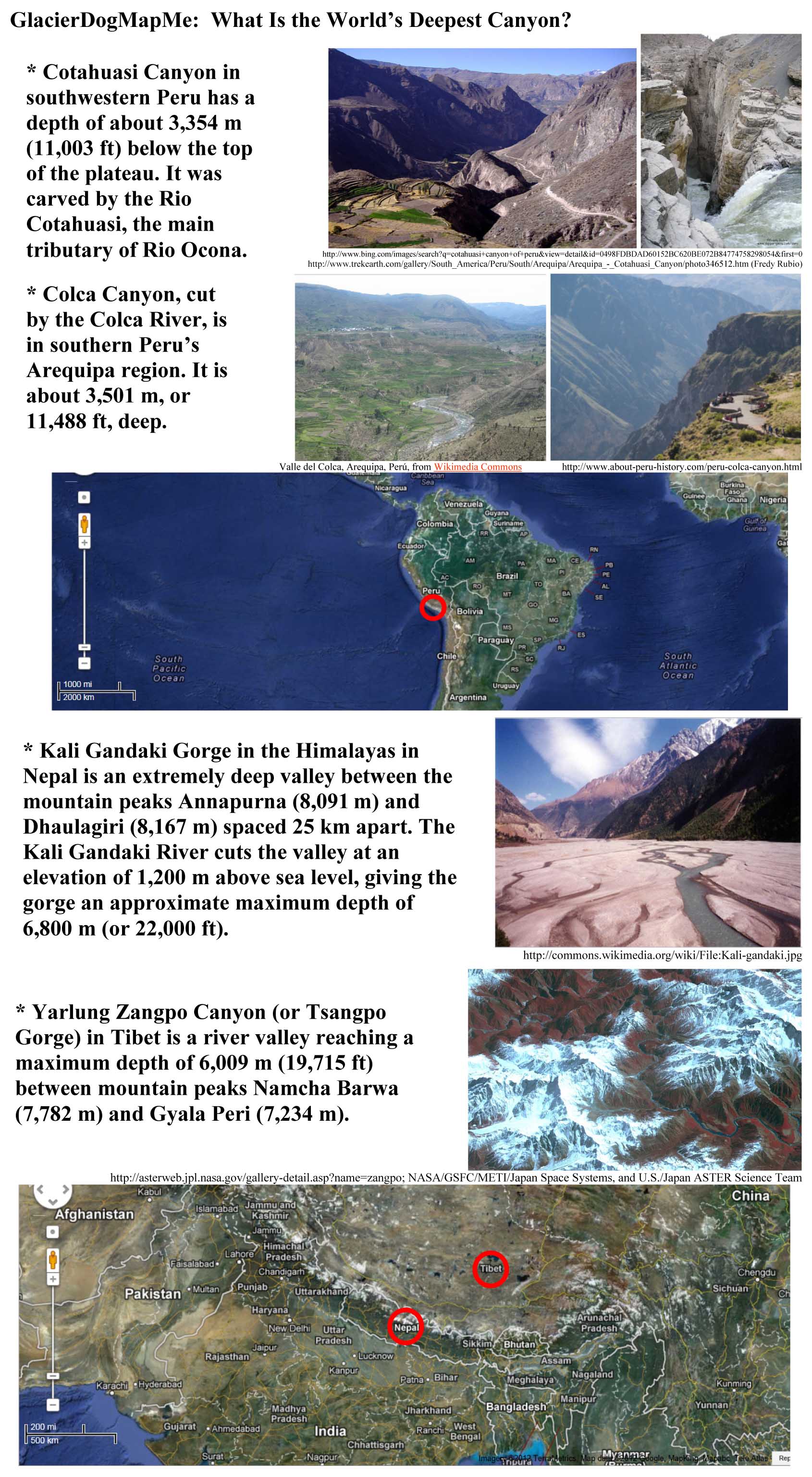
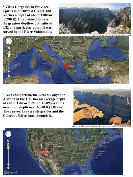
GlacierDogMapMe:
What Is the World’s Deepest Canyon? * Which canyon is deepest is debatable and depends on whether you are measuring a deep (narrow) chasm between two
(steep) mountains or a gorge between more vertical cliffs. As shown above GlacierDog’s top contenders are: Cotahuasi
Canyon and Colca Canyon in Peru, Kali Gandaki Gorge in Nepal, Yarlung Zangpo Canyon (or Tsangpo Gorge) in Tibet, and Vikos
Gorge in Greece. Sponsored by: http://www.glacierdogpublishing.com/
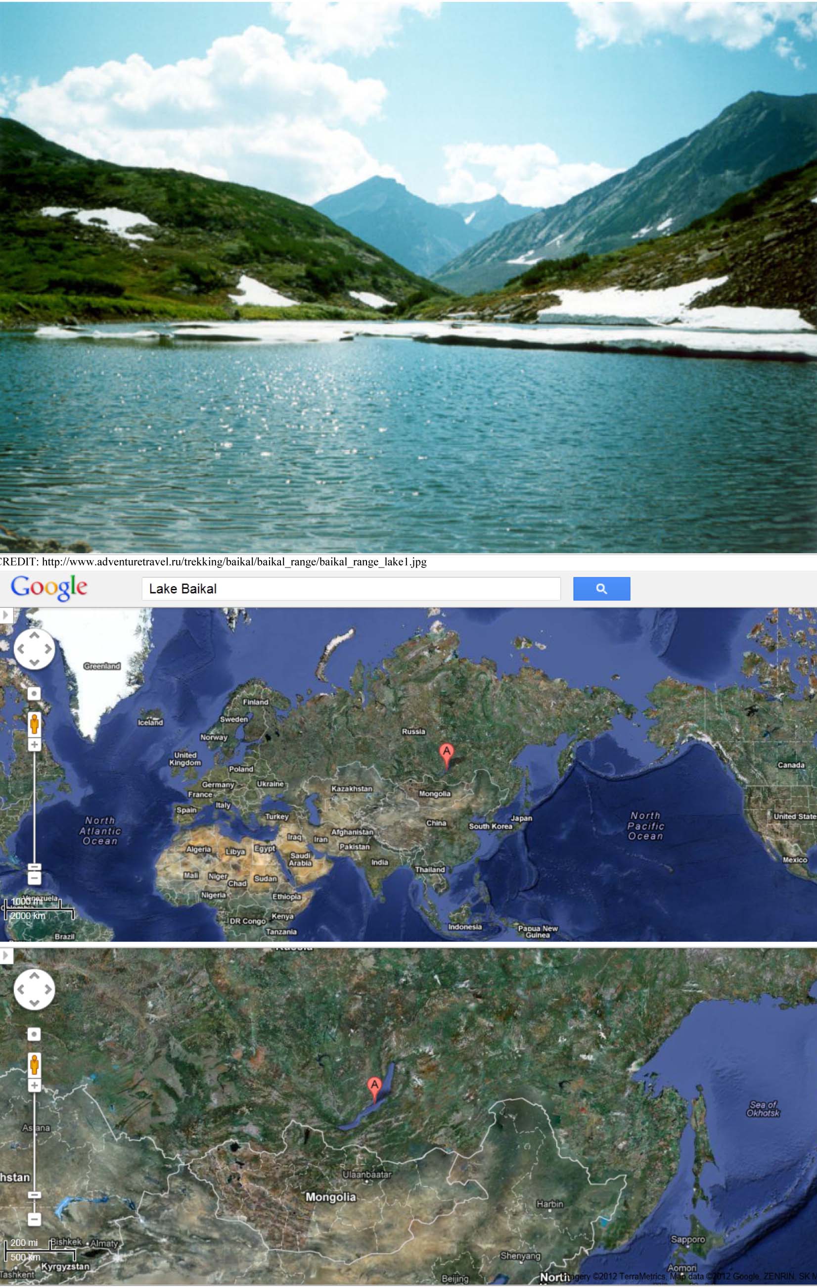
---------- GlacierDogMapMe: What Is the World’s
Deepest Lake?
MAPME GlacierDog: What Is the World’s Deepest
Lake? * Lake Baikal (or Baykal) is the
deepest lake in the world, over 1.6 km or 1 mi. * It curves through southern Russia for nearly 400 mi. * Lake Baikal is the largest freshwater lake by volume. Its
23,000 cubic km of water constitutes about 20% of the world’s total surface fresh liquid water. In fact, it has as much
water as all of the Great Lakes of North America combined. * It
lies in an active, widening continental rift zone. The sediments at the bottom are over 7 km (4 mi) thick, giving its rift
floor a depth of 8 to 9 km (over 5 mi).
|


